
Location: Launch from Stillwater Cove, Carmel, CA
Date: January 20, 2007
Type: WSK Trip
Stats: 5.4 miles, 2.5 hours paddling time
Click on the picture below to view an interactive track map. You can pan and zoom the interactive map to see details of different parts of the trip. It may take a few moments for the interactive map to load once you click below.
Interactive Google Map of the track log
Below is the link to a second interactive track map - showing both the 2006 Whale Rider and the 2007 Whale Rider on the same map. You can pan and zoom the interactive map to see details of different parts of the trip. It may take a few moments for the interactive map to load once you click below.
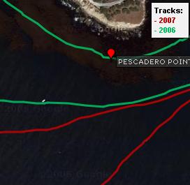
Interactive Google Map of the combined track logs
Below is the link to a third interactive track map - showing both the 2006 Whale Rider and the 2007 Whale Rider on the same map but without the waypoints. You can pan and zoom the interactive map to see details of different parts of the trip. It may take a few moments for the interactive map to load once you click below.

Track map without the waypoint names
